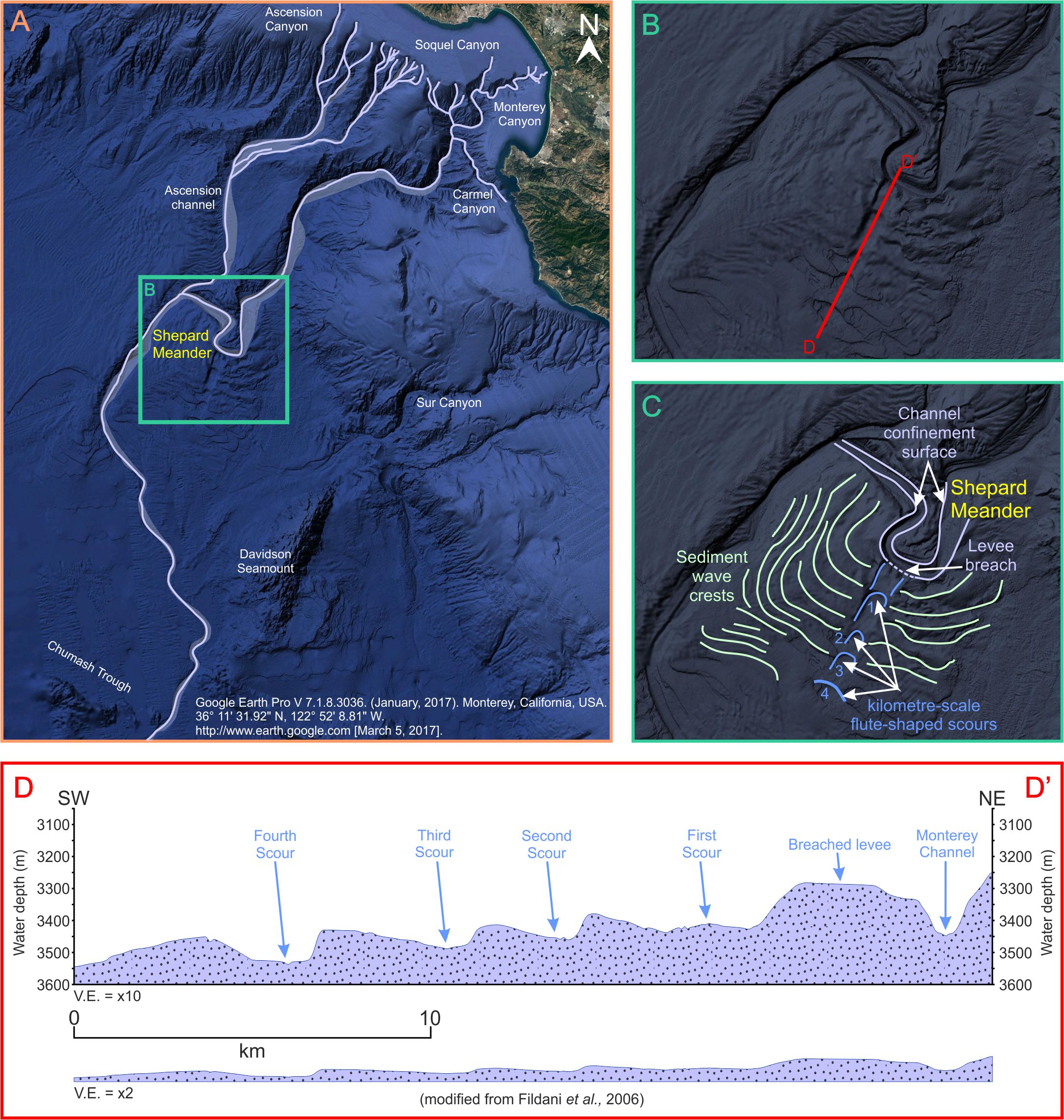
Figure A: Google Earth Pro image showing the geographical location of the Monterey Canyon, Monterey Channel and feeder canyons/channels. Figure B: Google Earth Pro image of the Shepard Meander, showing the D-D’ line highlights the location of the cross-section shown in figure D. Figure C: Google Earth Pro image showing the Shepard Meander, fully annotated. Figure D: A cross-section through the four large-scale scours that extend down-dip from the outer bend of the Shepard Meander, this cross-section has been modified from Fildani et al., 2006.
By Emma Morris: March. 2017
The modern Monterey Fan is one of the largest turbidite systems located off the west coast of the United States and you can see it on Google Earth!
It is a sand-rich system that has a radial shape (McHugh and Ryan, 2000) and is composed of ~600m (1969ft) of sediment that was deposited in less than 1 million years (Fildani and Normark, 2003). It is fed by a series of coalescing canyon systems that include the Monterey, Soquel, Carmel, and Ascension Canyons; the Monterey Canyon heads ~30m (98ft) from the shoreline, it is joined by the Soquel 18km (11.2mi) down canyon from the Monterey Canyon head (Greene et al., 1989) and the Carmel joins 30km (18.6mi) from the canyon head.
The lower submarine channels of the Ascension Canyon don’t join the Monterey until the base-of-slope at a water depth of 3290m (10794ft) (Greene et al., 1989; 2002). It should be noted that whilst the Ascension Canyon system supplied sediment to the Monterey basin floor fan system through the Ascension fan channel, that channel is now abandoned and no longer contributes to the growth of the Monterey Fan (McHugh and Ryan, 2000).
The main axis of the Monterey Canyon contains a thalweg that is ~250m (820ft) wide (typically between 100-300m (328-984ft) along its length) with a down canyon gradient of 1.8°.
The Shepard Meander
One of the most striking features of the Monterey Canyon and channel system is the Shepard Meander (Figures A, B and C), a horseshoe-shaped bend in the main channel system that is present at 3400-3540m (11155-11614ft) water depth (McHugh and Ryan, 2000). From the Google Earth Pro images of this prominent channel bend, a series of four, large-scale scours can be observed extending down-dip from a 3km (1.86mi) wide and 20-40m (66-131ft) deep breach in the outer bend levee bounding the Shepard Meander (Figure D). These scours are typically referred to as the Monterey East System, and they extend down dip from the Shepard Meander for 30km (18.6mi). These scours define the centreline of a 30km (18.6mi) wide area that is characterised by large-scale sediment waves that form a concentric pattern around the Shepard Meander (Fildani et al., 2006).
The four, large-scale scours are flute shaped, reaching 2.5-3.5km (1.6-2.2mi) wide, 2-5km (1.2-3.1mi) long and up to 110m (361ft) deep, they appear to shallow and broaden down-fan. The Monterey East System (or fan valley) could be considered a crevasse channel, although it does not have a continuous channel-axis. These scours have been sampled by short sediment cores that record fine-grained turbidite material, thought to be the products of flow-stripping whereby the finer-grained, uppermost fraction of the stratified turbidity flow is not fully contained within the channel confinement as the main turbidity currents navigates the Shepard Meander. Sediment accumulation rates within these scours has been calculated as more than five times the rate of accumulation on the Monterey-Ascension overbank areas sampled from a similar latitude (Fildani and Normark, 2004).
Fildani et al., (2006) suggest that both the sediment waves and the large-scale scours associated with the Shepard Meander are the result of cyclic steps, however, the sediment waves are interpreted as net-depositional cyclic steps rather than antidunes, whereas the scours are considered representative of net-erosional cyclic steps; this transition from net-depositional to net-erosional has been attributed to the focussing of flows through the breach in the outer bend levee on the Shepard Meander. Overall, it has been suggested that the Monterey East System is an incipient channel that may represent the early stages of an eventual avulsion from the current Monterey Channel system (Fildani et al., 2006).
No Comments Yet